Transport Development in BBL: Match Day Impact

Is the fencing still up, or can you cut across now?
If access is still restricted, what's the best way from BBL to the Stadium?
Fencing is still up ( being used as a clothes line at the last home game) and the contractors have ensured the cut throughs/ cut across exits are no longer usable by bulldozing 10ft plus high bounds across where the cut through /across paths/ exits were

Theres just the narrow alleyway from the steps/ ramp behind north stand to the top end of knights road... which is very slooooow moving post match
 
At least you won’t have the whole Thames valley police force giving you a guard of honour as you exit through the narrow alleyway unlike at the Reading game
 
Fencing is still up ( being used as a clothes line at the last home game) and the contractors have ensured the cut throughs/ cut across exits are no longer usable by bulldozing 10ft plus high bounds across where the cut through /across paths/ exits were

Theres just the narrow alleyway from the steps/ ramp behind north stand to the top end of knights road... which is very slooooow moving post match
Thanks.
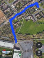
So should the path that I've highlighted blue be open this Saturday?
Screenshot_20240229_131553_Maps.jpg
 
It's a big housing development. This is the plan from the application.
I have drawn on the blue line at the top - which is Knights Road, and the blue line at the bottom - which is the bridge to the stadium. So the pathway which currently goes straight(ish) from the bridge to Knights Road will angle left instead before meeting up with the new roads which will then go up to Knights Road. I would say from what I have seen there will be no other way through.
1710768331113.png
 
I think @OUSP and @OxVox might need to check this out, this is the main route for fans getting a bus, walking or cycling from that side of Oxford!
The notice about the diversion (see attached) says:
"Any representation about or objection to the order may be sent or delivered in writing addressed to Mr Andrew Murdoch, Planning Services, Oxford City Council, Town Hall, St Aldates, Oxford, OX1 1BX or by email to planning@oxford.gov.uk not later than 25 March 2024. Please state the grounds on which it is made.If no such representations or objections are duly made, or if any so made are withdrawn, Oxford City Council may itself confirm the order as an unopposed order. "
 

Attachments

Where is the map of the divert?

old is solid line (points A D B), new is dashed line (points A C D E F G B).
 
I've just read on Facebook that from w/c 3rd February till mid April that the junction of Cuddesdon Way and Blackbird Leys Rd will be closed.
If you don't know the area too well this junction is by the Grey Brick Church with the unusual roof.
There are two junctions in close proximity to each other. Our friends at the council haven't said which junction, or maybe it's both.
With a 2 week gap between fixtures on 1st and 15th of February I'll update on the state of play before the fixture on the 15th.
 

Attachments

  • Screenshot_20250124_205523_Maps.jpg
    Screenshot_20250124_205523_Maps.jpg
    118.3 KB · Views: 18
Last edited:
The road will definitely be closed at the corner by Jakes Takeaway and the Library. So if you usually go up BBL Road from Pegasus Rd you'll have to find a new route. The road outside the shops will be the new main road when they've finished. Screenshot_20250127_145532_Facebook.jpg
 
Back
Top Bottom